Address Verification checks every address in a data source against Loqate’s global reference data, corrects and standardizes it, and appends the verified result as new columns alongside your original data. Your source records are never altered: the enrichment is written to a separate output data source that any other module in your workflow can use for further processing, such as matching, deduplication, cleansing, or export.
Three enrichments are available, and you can run any combination:
Which enrichments appear in your workspace depends on your license and the permissions your administrator has assigned to you.
When you open the Address Verification module you will see:
Hover over any question-mark icon for a short explanation of that control.
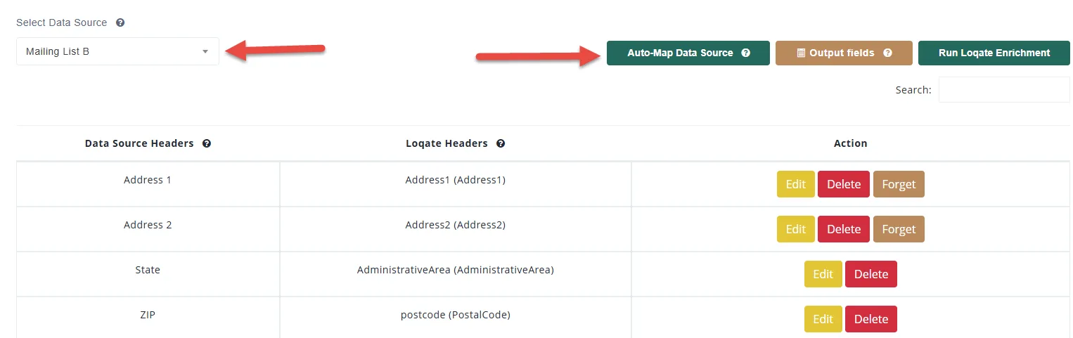
Loqate needs to know which of your columns contain which parts of an address. Mapping tells it, for example, that your “Address 1” column is the first address line and “State” is the administrative area.
Auto-Map. Click Auto-Map Data Source. Match Data Pro looks at each column header and matches it to a Loqate field using a built-in dictionary of common header names, plus any mappings you have told it to remember. Mapped columns move to the top of the table; unmatched columns stay listed so you can map them by hand.
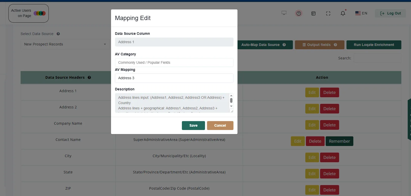
Manual mapping. Click Edit on any row to open the Mapping Edit dialog. Choose an AV Category, such as Commonly Used / Popular Fields, then the AV Mapping, and click Save. The Description box explains what the selected field expects, so you can confirm you have the right one. Each Loqate field can be used only once per data source. Click Delete to clear a mapping.
Remember and Forget. After you map a column by hand, click Remember and Match Data Pro will apply the same mapping to that header name automatically the next time you Auto-Map any data source. Click Forget to remove a remembered mapping.
Which fields to map. At a minimum, map the fields that identify the address: the street address line(s), city, state or region, and postal code. Loqate accepts addresses as separate components (Thoroughfare, Premise, Locality, AdministrativeArea, PostalCode) or as free-form lines (Address1 through Address8). Map what you have and Loqate parses the rest. If your data has an Organization column, map it too, since business names improve CASS matching.
Country. If your data has a country column, map it to Country; Loqate accepts country names, 2-letter codes (US), or 3-letter codes (USA). If there is no country column, you will pick a single country for the whole data source when you run the enrichment.
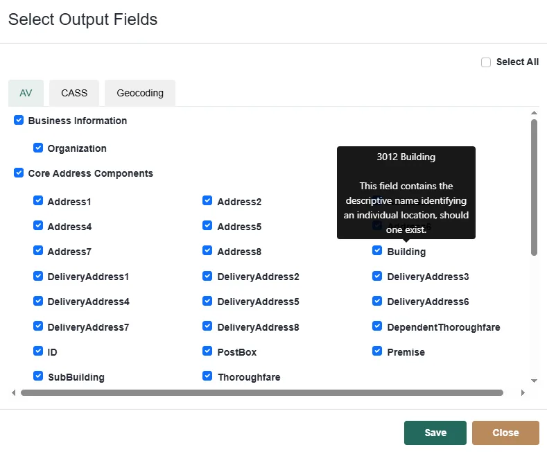
Click Output fields to choose which verified fields are added to your data. The dialog has one tab per enrichment, and only the tabs you are licensed for are shown:
Use Select All to take everything, tick a group heading to take a whole group, or tick individual fields. Hover over a field for a description. Your selection is saved with the project and reused on the next run.
Templates. If you use the same set of fields across projects, click Save Template, give it a name and description, and later click Load Template to apply it. Templates are personal to your login.
If you select nothing, Match Data Pro appends a standard set of the most useful fields: the parsed address components, postal code, country name and ISO code, latitude, longitude, GeoAccuracy, and the AVC.
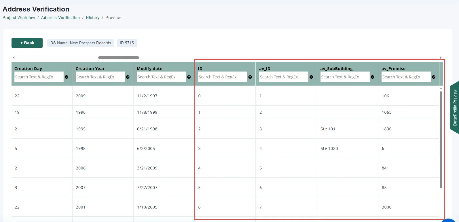
Every appended column is prefixed with av_ so you can tell verified fields from your originals at a glance, for example av_PostalCode and av_AVC.
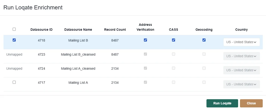
Click Run Loqate Enrichment. The Run dialog lists every data source in the project with its record count.
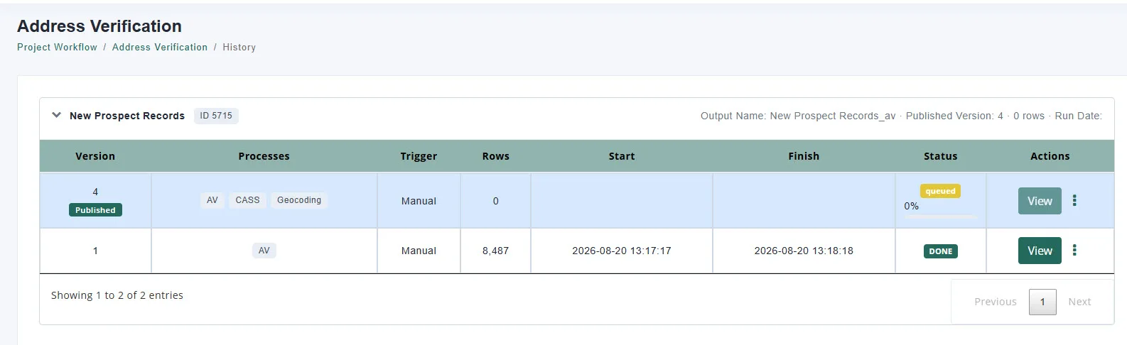
You are taken to the History page, where the job appears as queued and then running with a progress bar. Verification runs in the background, so you can leave the page and come back. Run time depends on the number of records and the enrichments selected.
The History page groups runs by data source. Each group header shows the Output Name (the name of the result data source, which is your data source name with an _av suffix), the currently Published Version, its row count, and the run date. Expand a group to see every version with:
Actions
Each run creates a new version, so you can re-run with different fields or enrichments and compare before publishing.
Automation. Once the module is configured, it runs as part of the project whenever the project is launched through the Automation module: by API call, by the Run button that launches the entire project manually, or by the scheduler. Those runs show Automation as the trigger in History.
Three appended fields tell you how much to trust each result.
The AVC is the field to use when deciding whether to accept an address. It looks like V44-I44-P6-100 and reads left to right:
| Part | Example | Meaning |
|---|---|---|
| Verification status | V | V = Verified (full match), P = Partial match, A = Ambiguous (several close matches), U = Unverified (could not be verified; your input is returned), R = Reverted (did not meet the minimum standard; your input is returned) |
| Post-processed match level | 4 | How much of the address matched after Loqate’s corrections, on the 0–5 scale below |
| Pre-processed match level | 4 | How much matched before corrections |
| Parsing status | I | I = Identified and parsed, U = Unable to parse fully |
| Lexicon level | 4 | How much of the address Loqate recognized from its dictionaries (0–5) |
| Context level | 4 | How much was recognized from its position in the address (0–5) |
| Postcode status | P6 | P0 (no postcode) up to P8 (both primary and secondary postcode verified) |
| Match score | 100 | Similarity between your input and the matched reference, 0–100 |
Match levels (0–5): 5 = Delivery point (PO box or sub-building such as a suite), 4 = Premise or building, 3 = Street, 2 = Locality or postal code, 1 = Administrative area (state or region), 0 = No match.
A practical rule of thumb: an AVC starting with V4 or V5 is a fully verified, deliverable address; V3 is verified to street level; P results were partially matched and are worth a look; U and R results could not be verified.
A single letter summarizing quality: A Excellent (verifiable to premise level without changes), B Good (street level with minor changes), C Average (locality level with moderate changes), D Poor (locality level with major changes), E or blank: could not be parsed. AQI is useful for reporting; use the AVC for accept-or-reject decisions.
A two-character code returned with Geocoding, for example P4:
So P4 is a rooftop-level point, I3 is an estimate along the street, and U0 means no coordinates could be found.
Field descriptions are summarized from Loqate’s documentation: Address fields, CASS fields, Geocode fields. Expand a section to see the fields.
| Field | Description |
|---|---|
| ID | Your record identifier, passed through unchanged. |
| Address1–Address8 | The verified address split into mailing lines in the country’s format. |
| DeliveryAddress, DeliveryAddress1–8 | The address without the organization and the locality/postal lines, split into lines. |
| Organization | Business name at the delivery point. |
| Building | Descriptive building name. |
| Premise | Building number or code. |
| SubBuilding | Apartment, suite, or unit. |
| PostBox | PO Box designation. |
| Thoroughfare | Street name. |
| DependentThoroughfare | Secondary street, where used. |
| Locality | City or town. |
| DependentLocality | Smaller area within the locality (neighborhood or district). |
| DoubleDependentLocality | Smallest area within a dependent locality. |
| AdministrativeArea | State, province, or region. |
| SubAdministrativeArea | County or district. |
| SuperAdministrativeArea | Largest division within a country, where used. |
| PostalCode | Full postal code. |
| PostalCodePrimary | Main postal code (5-digit ZIP, UK postcode, PIN). |
| PostalCodeSecondary | Secondary code (ZIP+4 add-on). |
| CountryName | Official country name. |
| ISO3166-2 / ISO3166-3 / ISO3166-N | Two-letter, three-letter, and numeric ISO country codes. |
| AVC | Address Verification Code (see Reading the Results). |
| AQI | Address Quality Index (see Reading the Results). |
| Field | Description |
|---|---|
| DPVConfirmedIndicator | Deliverability: Y = confirmed, N = not deliverable, S = primary number confirmed but the secondary (suite/apt) is invalid, D = primary confirmed but the secondary is missing, blank = not checked. |
| EnhancedReturnCode | A more detailed DPV result (Y, D, S, N, R); when present, it takes precedence over DPVConfirmedIndicator. |
| DPVFootnotes | Two-letter codes explaining the DPV result (for example AA = ZIP+4 matched, BB = all components confirmed, M1 = primary number missing, M3 = primary number invalid). |
| VacantIndicator | Y if the address is vacant and not receiving mail. |
| CMRAIndicator | Y if the address is a commercial mail receiving agency (private mailbox store). |
| ThrowbackIndicator | Y if the address receives mail at a PO Box instead of the street address. |
| Zip5Valid | Whether the ZIP5 counts as valid on USPS Form 3553. |
| DNA | Y if the door is not accessible for package delivery. |
| NSL | Y if there is no secure location to leave packages. |
| NDDFlag / NDDValues | Whether mail is delivered every weekday, and a seven-character Sunday-to-Saturday pattern of delivery days. |
| NoStatIndicator / NoStatReason | Y if the address is not currently receiving delivery, with a reason code. |
| FalsePositiveIndicator | Y if the address is a USPS false-positive seed record. |
| DropSiteIndicator | Y if mail for several units is delivered to a single receptacle. |
| PBSAIndicator | Y if the address is a PO Box street address. |
| POBoxOnly | Y if the ZIP Code has PO Box delivery only. |
| CarrierRoute | Carrier route code: C = city delivery, R = rural route, H = highway contract, B = PO Box, G = general delivery. |
| AutoZoneIndicator | Carrier route sort rate applicability (A/B/C/D). |
| Finance | USPS finance number for the postal facility. |
| CongressionalDistrict | Congressional district for the address. |
| FIPSCountyCode | Five-digit federal code identifying the county. |
| PostalCode / PostalCodePrimary / PostalCodeSecondary | ZIP+4, ZIP5, and the four-digit add-on. |
| DeliveryPointBarCode / CheckDigit | Delivery point code and check digit for the POSTNET barcode. |
| eLOTCode / eLOTNumber | Enhanced Line of Travel sequence number and direction (A ascending, D descending) used for carrier sorting. |
| ResultsString | Detailed processing result codes from the CASS engine. |
| ReturnCode | Match status: 31–32 matched, 21–22 no match or multiple matches, 10–13 invalid input. |
| RecordType | Type of address confirmed: S = street, P = PO Box, R = rural route, H = high-rise, F = firm, G = general delivery. |
| DefaultFlag | Y when the match was to a default record (for example a high-rise without a valid unit). |
| EWSFlag | Y if the address is in the Early Warning System (new addresses not yet in the main database). |
| ParsedGarbage | Input text the CASS engine could not assign to any address field. |
| ResidentialDelivery | Y = residential, N = business, blank = unknown. |
| SUITELinkFootnote | A when SuiteLink improved a business address with a suite number; 00 when not. |
| LACSLinkCode / LACSLinkIndicator / LACSStatus | Whether a rural-style address was converted to a city-style address via LACSLink, and the result. |
| Organization, PrimaryAddressLine, SecondaryAddressLine, DeliveryAddress, DeliveryAddress1–3 | The standardized USPS address lines. |
| Premise, Thoroughfare, ThoroughfarePreDirection, ThoroughfareName, ThoroughfareTrailingType, ThoroughfarePostDirection | Parsed street components: number, N/S/E/W prefix, name, type such as ST or AVE, and suffix direction. |
| SubBuilding, SubBuildingLeadingType, SubBuildingNumber | Parsed unit designator (for example STE) and number. |
| PostBox, PostBoxType, PostBoxNumber | Parsed PO Box. |
| PMBType / PMBNumber | Private mailbox designator and number at a commercial mail receiving agency. |
| Locality, DependentLocality, SubAdministrativeArea, AdministrativeArea | City, urbanization (Puerto Rico), county, and state. |
| Field | Description |
|---|---|
| Latitude | WGS 84 latitude in decimal degrees. |
| Longitude | WGS 84 longitude in decimal degrees. |
| GeoAccuracy | How the point was determined and at what level (see Reading the Results). |
| GeoDistance | Radius of accuracy in meters: the likely maximum distance between the returned point and the actual location. |
No. Your source data source is untouched. The verified fields are appended as new av_ columns in a separate output data source.
Address Verification and Geocoding support over 245 countries and territories. CASS is a USPS certification and applies to United States addresses only.
They are kept in the output with your original values and an AVC beginning with U (unverified) or R (reverted). Filter on av_AVC to find them.
No. If you leave the selection empty, a standard set of address components, postal code, country, coordinates, GeoAccuracy, and AVC is appended.
Yes. Tick as many data sources as you need in the Run dialog. Each is processed as its own job with its own history and versions.
Yes. Once the module is configured, it runs whenever the project is launched through the Automation module, whether by API call, by the Run button that launches the entire project, or by the scheduler. Those runs show Automation as the trigger in History.
Publish the version you want, then select the output data source (your data source name with the _av suffix) in Fuzzy Matching, Data Cleansing, Data Export, or any other module.
It has no column mappings yet. Select it on the main screen, click Auto-Map Data Source or map columns manually, and then run.
At Match Data Pro, our core focus is fuzzy data matching and entity resolution but our platform goes far beyond that
Copyright 2026 Match Data Pro. All Rights Reserved